
Southeast Land Trust Partners with Taking Action for Wildlife
Taking Action for Wildlife staff Amanda Stone and Emma Carcagno had the opportunity to assist a NH land trust to engage with local communities over the past several months using a new and exciting technology. SELT (previously known as Southeast Land Trust of NH), which currently serves most of Rockingham County and much of Strafford County, completed a new strategic plan earlier this year. As part of that process, the land trust recognized a need to update their conservation focus areas to help direct their future work.
This type of work is often done at a computer. You can use existing resources, such as the Wildlife Action Plan maps, water resources maps, maps of existing conservation land, and soils maps (to name just a few) to determine where important resources might overlap, which may help narrow down areas that are important to conserve. It is, however, also important to gather local knowledge and input to help pick out areas that may not be identified on state-wide maps. Knowing this, Southeast Land Trust, sought to hold regional meetings throughout Rockingham County, inviting town Conservation Commissions to come and share the areas that are important in their towns. Hearing about this interest, the Taking Action for Wildlife team recognized their unique position to be able to assist in this effort using a new and innovative technology called WeTables and the Wildlife Action Plan maps.
WeTables are a participatory mapping tool that allows us to project a digital picture of a map onto a table using a laptop computer and a LCD projector mounted on a tripod. Participants can gather around the table and use an infrared pen to draw digitally on the map, identifying locally important areas for conservation. An “eraser” allows participants to alter and redraw parts of the boundaries of the focus area for better definition. We can then save those drawings on the computer for the land trust to incorporate into their map analysis.
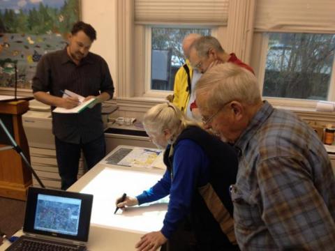
Members of the Durham and Lee Conservation Commissions identify areas that might be important for conservation using the new WeTable technology. Photo by Malin Clyde.
Southeast Land Trust organized and hosted five regional meetings, inviting all 39 towns in their current service area to attend. Taking Action for Wildlife Team members, Emma and Amanda, introduced the Wildlife Action Plan maps, and helped to facilitate the use of the WeTables. The focus of the exercise was primarily on the wildlife maps (habitats land cover and highest ranked habitats) along with water resources maps. A number of conservation commissioners participated, circling areas on the map in their towns, discussing and identifying potential conservation focus areas with local significance for wildlife and water resources.
“Like with any new technology, there are definitely pros and cons to the using the WeTable,” noted Southeast Land Trust’s Land Protection and Stewardship Specialist, Dave Viale, “but overall it was a useful tool for engaging people in a new way. The information we gathered from towns will be valuable in helping us to identify our own focus areas.” With the upcoming merger, Southeast Land Trust will be adding 13 more towns to its service area, so it will likely be several months before they are able to finalize their conservation focus areas - we look forward to seeing the final product!