Communities Take Action on Climate Change
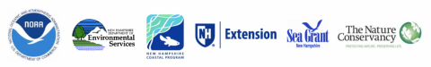
Photo by Bob McGrath
In coastal New Hampshire, many planning board members and municipal staff have been engaged in climate adaptation projects, such as vulnerability assessments and planning initiatives. However, conservation commissions have typically not been as involved in these efforts. Since 2017, Taking Action for Wildlife team members Amanda Stone (UNH Extension) and Lisa Wise (NH Sea Grant & UNH Extension) have been meeting with coastal conservation commissions to share climate-related information that is specifically relevant for land and water quality protection.
In 2016, The Nature Conservancy released the Land Conservation Priorities for the Protection of Coastal Water Resources: A Supplement to The Land Conservation Plan for New Hampshire’s Coastal Watersheds (2006). The 2016 Water Resources Update data covers the coastal watershed and identify areas that provide one or more of the following benefits:
- Flood storage
- Salt marsh migration opportunities
- Water quality protection
- Public water supply protection
And of course, what is good for protecting water resources, is also good for protecting wildlife and habitats!
These benefits are important to begin with but even more so in the context of climate change, which is causing rising sea levels and groundwater levels, more extreme precipitation, and potentially increased drought impacts due to rising temperatures. The data can be explored via the NH Coastal Viewer.
This outreach to conservation commissions began in 2017 with the NH Setting SAIL Project, during which Stone and Wise brought information from the NH Coastal Risk and Hazards Commission Report to coastal conservation commissions and discussed actions they could take to more explicitly consider climate impacts to natural resources in their work. The effort continued into the 2018-2019, focused on the 2016 data from The Nature Conservancy. Stone and Wise brought community-specific maps of the data plus this simple handout describing the available data to meetings with 11 conservation commissions in the coastal watershed. Over 100 people participated in these meetings (primarily conservation commission members as well as other board members, municipal staff, and community members). A number of communities also expressed interest in including Wildlife Action Plan data and climate change impacts in their natural resources and conservation planning documents, as well as the Water Resources update data.
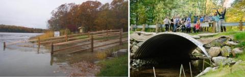
(Left) Living shoreline project in Durham, NH. Photo by Todd Selig. (Right) Volunteers at a stream restoration workday. Photo by UNH Extension.
The table below summarizes conservation commissions’ actions resulting from or informed by the Water Resources Update Project:
| MUNICIPALITY | COMPLETED ACTIONS | ACTIONS IN PROGRESS |
|---|---|---|
| Barrington |
|
|
| Dover |
|
|
| Exeter |
|
|
| Greenland |
|
|
| Hampton |
|
|
| Hampton Falls |
|
|
| North Hampton |
|
|
| Rye |
|
|
By Lisa Wise, NH Sea Grant and UNH Extension & Amanda Stone, UNH Extension
Winter 2020 Taking Action for Wildlife Newsletter
This project was funded by the Coastal Zone Management Act, 16 U.S.C. 1451-1466, administered by the Office for Coastal Management, National Oceanic and Atmospheric Administration, in conjunction with the NHDES Coastal Program.