
Taking A Wildlife View to Trails
It was a cool rainy summer morning, when I set out along the trails on the Cedar Run/Jim Raynes Forest with members of the Rye Conservation Commission and Rachel Stevens, a consultant and wildlife biologist. The property is a lovely hidden gem of oak-pine woodlands outfitted with wetlands and dotted with vernal pools tucked in behind a couple small developments. The property is owned by the Town of Rye and managed by the Conservation Commission. They had asked me to evaluate the potential ecological impacts of the existing trails and supporting infrastructure as a case study on how to approach trails and public access on all their conservation areas.
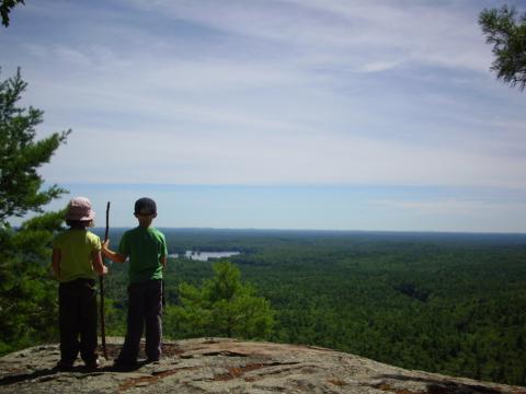
Photo by Paul Stevens
The personal and community benefits of access to the outdoors are well documented, and many people explore the outdoors using trails found on public lands. In many communities there is an expectation that all town conservation areas have trails and public access. But town conservation areas provide a diversity of public benefits beyond public access, from scenic vistas, to water quality protection and wildlife habitat. The challenge is finding the balance between various public benefits and different outdoor recreational users. This was the question the Rye Conservation Commission was interested in understanding.
Their motivation for the trails inventory was driven by concerns that conservation areas appreciated for their relative remoteness and wildlife were at risk from increases in trail use. Although trails and their use have less of an impact than say commercial development, there are impacts to wildlife behavior, abundance, and survival. These small changes can have cumulative impacts. The extent of these impacts depends on the species as well as the type and frequency of trail use. In addition to disturbing wildlife species, trails can have impacts to the habitats that support the wildlife species including fragmentation, erosion, soil compaction, and changes in water flow.
Glenn Suchocki and Mike Garvan from the Rye Conservation Commission both agreed that the preliminary site walk was pivotal in their decision to evaluate all of their properties and not just a couple. Mike identified the specific benefits, “The site walk helped us recognize a wider breadth and depth of trail considerations than we first realized, understand what could be done and focus on what needed to be done.”
They decided to hire a consultant to complete a trails inventory of all their town conservation areas – nine altogether. Based on the project objectives identified during the site walk, the Commission drafted a Request for Proposals (RFP) and ultimately decided to hire Rachel Stevens from Birch Tree Conservation Consulting because of her extensive experience in both trails management and wildlife.
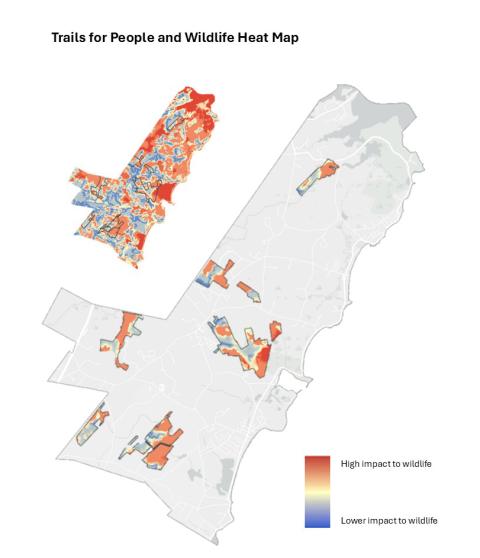
Heat Map from An Inventory of Trails and Assessment of Potential Impacts to Wildlife on Town Conservation Lands in Rye, NH. 2026.
The trail inventory included both site walks on all trails (including rogue or bootleg trails) and an analysis with NH Fish and Game’s Trails for People and Wildlife mapping tool. Stevens emphasized the importance of including both “The pairing of GIS (geographical information) with field work gives you different but complementary perspectives on your trails evaluation.”
Walking the trails with Rachel also enabled Commission members to learn about trail uses, intensity, physical conditions, and concepts of building a resilient trail system. Many of the same considerations that pertain to wildlife also support a resilient trail system. For example, trails within wet areas and steep slopes degrade quickly and often require costly structures or long-term maintenance. Avoiding these areas help protect more sensitive wildlife habitats and can contribute to trail longevity.
Rye believes one of the most important pieces to their trails inventory process was their effort to engage their community early and often. They invited members of the public to all of their site walks, which were attended by Commission members and Rachel. This enabled regular users to offer their perspectives and information about trail history but also learn about the project goals.
“Using the trails for people and wildlife mapping tool is more powerful when you review trails throughout a community and not just one or two properties at a times” says Stevens, “It allows you to compare properties and decide if the property is more amenable to recreational uses or where sensitive ecology or wildlife habitats exist that would be impacted by developed public access. As a community aims to meet the needs of different types of outdoor users, it is helpful to understand where the best natural spaces for these uses to take place.”
The analysis on Rye’s conservation areas clearly identified two properties that best support public access – so called “ambassador properties” - and two that would benefit from limited public access to protect sensitive and important wildlife and habitats.
The report provides recommendations solely on the science and ecology. Other factors, such as social and historical context understood and expressed by the community, also contribute to trail decisions. With that in mind, the report includes suggested limitations on certain uses that reduce impacts to sensitive habitats if they choose to keep trails open, such as limiting horseback riding, requiring dogs on leash, or re-routing a trail.
In reflecting on the inventory and recommendations, Commission member Glenn Suchocki noted the benefits of the process: “The Rye Conservation Commission felt it was important to have objective and professional assessment of all of their trails. The trail inventory gives us the ability to make informed decisions about which properties to maintain trails on, which ones to close and validate these decisions to the public.”